|
Hal Shelton Revisted: Designing and Producing Natural-Color Maps with Satellite Land Cover Data Tom Patterson, US National Park
Service PREVIOUS: NATIONAL LAND COVER DATASET |
MODIS
VEGETATION CONTINUOUS FIELDS
MODIS VCF (Vegetation Continuous Fields) is the second type of land
cover data that we examine. It consists of three data layers
representing forest, herbaceous, and bare land cover. Although three
land cover categories may seem scant, VCF data possesses unique
qualities that are amenable to making generalized natural-color bases.
Afterwards, color modifications and additional data are applicable to
the VCF bases as needed.
Fuzzy data
VCF is the product of two organizations. Like the “Blue Marble”
discussed earlier, it originates from the MODIS sensor aboard NASA’s
Terra satellite platform, which traverses the entire Earth every one to
two days in a polar orbit. The University of Maryland, Global Land
Cover Facility created VCF from raw MODIS data collected by NASA in
2000 and 2001. The final 500-meter-resolution land cover data derives
from monthly composites (they use seven bands of spectral information
with emphasis given to bands 1, 2, and 7) processed to remove clouds
and cloud shadows (Hansen et al., 2003).
Coverage includes all terrestrial areas of the planet except Antarctica
and the polar fringes of Canada, Greenland, and Siberia north of 80
degrees latitude. VCF land cover layers for each continent (up to
several hundred megabytes apiece) are downloadable for free from the
University of Maryland website in either the Geographic or the
Interrupted Goode Homolosine projections. If you plan on reprojecting
these data, choose the Geographic projection, which is better suited
for use with most GIS and cartographic software. MODIS VCF data layers,
provided in BIL (Band Interleaved by Line) format, readily open in
Photoshop or GIS software. Note: Photoshop only opens single-channel
(i.e. grayscale) BIL files in “Raw” file format, so make sure to note
the row and column dimensions (in pixels) prior to opening the file.
Downloads also include metadata and projection information (see
Appendix B).
Unlike hard categorical land cover data such as NLCD, MODIS VCF
consists of a matrix of continuous tone values. For any given 500 x
500-meter sample of Earth’s surface, grayscale pixels represent the
three land cover categories as percentages. Together they add up to 100
percent. For example, Figure 14 shows forest,
herbaceous, and bare land cover for Africa loaded into the Red, Green,
and Blue channels of an RGB image—a quintessentially scientific choice
of colors. A sample selected from the relatively lush savannah of East
Africa shows the content as 38 percent forest and 62 percent
herbaceous. By comparison, a sample from the Sahara registers as 100
percent bare, as one would expect, given the extreme aridity of that
region. Elsewhere in Africa the three land cover categories blend
softly with one another much as vegetation does in nature. They also
combine to form intermediate categories. Bare desert gradually
transitions to semi-desert, semi-desert to herbaceous grassland,
herbaceous grassland to savannah, and savannah to forest. Compared to
categorical land cover data, this model better represents nature and
Shelton’s painted art where there are few stark boundaries between
vegetation types.
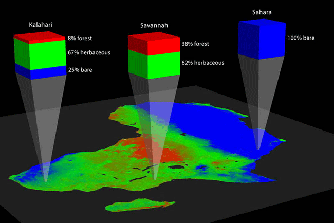
Figure
14. Blended lands cover categories in MODIS VCF. The combined
values for any sampled pixel on the map are 100 percent.
Given the global extent, 500-meter resolution, and general nature of
MODIS VCF land cover data, this product is most appropriate for making
natural-color maps at small and medium-scales. Next, we will make a
natural-color map of North America. With diverse natural environments
ranging from tropical rainforests to ice caps, North America is a
rigorous test of the capacity of VCF for natural-color map design.
Using
MODIS VCF in Photoshop
Having downloaded, decompressed, and, perhaps, reprojected VCF, you
will next need to open it in Photoshop as a raw raster file from the
File/Open dialog. Note: to open Eurasian VCF layers that are more than
42,000 pixels wide requires Photoshop CS (v. 8.0) or later. North
America and the other smaller VCF tiles are accessible to earlier
versions of Photoshop, which are limited to a maximum file width of
30,000 pixels. When opened in Photoshop, VCF land cover appears as an
ordinary 8-bit grayscale image. White areas on the image represent open
water, so in effect VCF provides you with a bonus fourth category of
information. The forest, herbaceous, and bare information appear as
grayscale values with lighter values representing greater densities.
They are analogous to photographic negatives. This trait makes VCF
amenable for use as layer masks for modulating colors in Photoshop.
After opening each VCF data layer as a separate Photoshop file, combine
them into one multilayer image as follows:
- Create a new
Photoshop document with exactly the same pixel dimensions as the VCF
data you just opened.
- Create five
new layers by selecting Layer/New Fill Layer/Solid Color in the drop
menu or by clicking the “Create a new layer” button in the Layers
palette.
- Name the
layers white background, herbaceous, forest, bare and water
respectively from bottom to top.
- Fill each
layer with an exploratory color. Use white for the background, green
for forest, yellow-green for herbaceous, beige for bare, and blue for
water (these colors can be fine-tuned later in the design process).
- Create a
layer mask for each of the layers by selecting Layer/Add Layer Mask/
Reveal All, or by clicking the “Add layer mask” button in the Layers
palette.
- (a) To insert
the VCF land cover data into their respective layer masks, copy and
paste the data. Tip: you need to Option-click (Mac) or Alt-click (PC)
on the Layer mask thumbnail to open the Layer mask itself for the
pasting to occur.
(b) Alternatively, you can use the Apply Image dialog (Image/Apply Image) to insert the VCF land cover data into Layer masks (all VCF files intended for insertion must be open). First click the Layer mask thumbnail to activate it. Then open the Apply Image dialog and choose one of the VCF files as the source image. The target is by default the Photoshop file you are currently working in. Set blending to normal and opacity to 100 percent. Repeat these steps to insert for the two remaining VCF data files.
- To color the
land cover layers at the full intensity as chosen in step 4, activate
the VCF layer mask for each layer mask as described in 6b above. Then
use the Levels dialog (Images/Adjustments/Levels) to convert the
grayscale data into a high contrast mask by adjusting the Input Levels
settings to 0, 1.00, and 100 respectively from left to right.
- To prepare
the water layer, insert any one of the three VCF data files into the
Layer mask on that layer. First, activate the Layer mask. Then use the
Brightness/Contrast dialog (Image/Adjustments/Brightness/Contrast) to
convert the grayscale data into a high contrast land/water mask by
setting the contrast slider to plus 100. Lastly, invert the mask so
that water areas appear white (Image/Adjustments/Invert).
Color
adjustments
When finished you should have a Photoshop file that looks similar to Figure 15 (left side). Although preparing MODIS VCF
for use in Photoshop is complex, the resulting file permits the easy
application of colors to the data. We will start by globally colorizing
the vegetation colors. Double clicking the foreground color in the Tool
palette brings up the Color Picker and using the Fill command
(File/Fill) delivers the new color to the layer (remember to click on
the Layer thumbnail before filling). Assigning new colors to the
forest, herbaceous, bare, and water layers takes only minutes. Changing
the master opacity (keep the blending mode as normal) or manipulating
the VCF grayscale data in the layer masks permits even finer global
color adjustments. For example, to bring more emphasis to low-density
forests use Curves (Image/Adjustments/Curves) to increase the value of
these areas. In the North American example, employing this technique
made the arctic tree line more distinct.
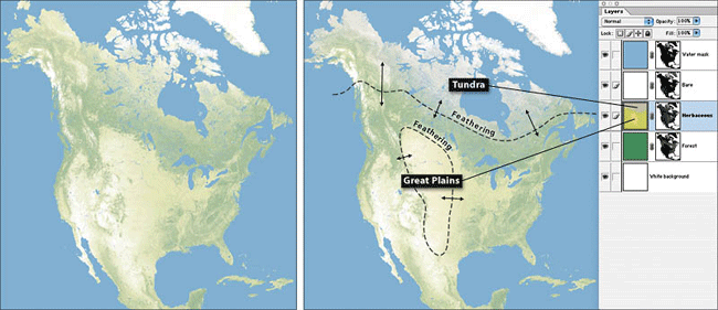
Figure 15. (left) MODIS VCF in Photoshop presented as uniform colors.
(right) With environmental color adjustments applied to the herbaceous
layer.
Another even more powerful option is to locally adjust colors based on
environmental factors. Doing this creates new land cover categories and
adds geographically relevant color variations to the map. For example,
in Figure 15 (left side) herbaceous land cover
appears as the same yellow-green whether it shows cornfields in Iowa,
rangeland in Montana, or tundra in Nunavut. Contrast this with Figure 15 (right side), where local color adjustments
depict rangeland as yellow-gold and tundra as light gray-green.
Applying local color adjustments is technically simple—just draw a
selection boundary with the Lasso tool, apply feathering
(Select/Feather) to taste, and fill with a new color. A more critical
concern, however, is where the color adjustments are applied and the
colors used. For accomplishing this task biogeography and climatic
references are a must. Returning to the example of North American
tundra, we considered a number of geographical definitions of the
arctic for delineating this environmental zone. The
10-degree-centigrade isotherm for July average temperature, for
example, generally defines the northern limit of trees worldwide. This
definition, however, proved inadequate for subarctic regions, such as
Labrador, where tundra-like muskeg and spruce-lichen woodland extend
southward for hundreds of kilometers. To bring tundra coloration to
these deserving areas we drew the diffuse southern boundary of the
tundra zone to include the northern third of the boreal forest zone.
Because the tundra coloration applies only to herbaceous land cover,
the green forests remained undisturbed.
We applied similar environmental color adjustments to the bare VCF
layer to accentuate the polar desert of the high arctic (muted purple),
alpine areas (light gray), and the hot southwestern deserts (light red
brown). Many other local adjustments are possible. For instance,
according to the Köppen climate classification system, the
18-degree-centigrade isotherm for January average temperature defines
tropical areas in the northern hemisphere. A slight increase in
saturation for all land cover categories within this area (delineated
by a diffuse boundary) would increase the vibrancy of tropical
areas—bringing the colors on the map closer to our perceptions of
geographic reality. Considering that tropical areas in North America
account for a small percentage of the total area, as an added benefit
(and depending on the design goals of the map) brighter natural colors
could bring needed emphasis to the tropics.
Accessorizing MODIS VCF
MODIS VCF is not a complete data solution for making natural-color
maps. While the natural manner in which it blends colors into one
another is highly effective, it lacks important land cover categories
one would expect to find on a map. To bring a natural-color map based
on VCF to final completion requires supplemental data. For example, in
VCF the “bare” category does not differentiate between sand, rock, and
permanent ice and snow, etc. Any surface without biomass receives the
bare classification, be it a gravel bar in Alaska or the concrete
skyscrapers of Manhattan. Looking again at the map of North America,
glaciers in northern Canada and Greenland appear with the same white
color as the surrounding bare ground, rendering them invisible (Figure 15, left and right). Fixing this problem
involved three steps—and two days of work. First, using the color
adjustment technique discussed previously, we assigned a muted purple
tint to all bare areas (including the glaciers) in the high arctic to
depict polar desert. Next, we reprojected, rasterized, and imported DCW
(Digital Chart of the World) vector data at 1:2,000,000-scale as white
polygons, which contrasted with purple background in VCF to show
glacier shapes. As a final touch, in Photoshop we overprinted the white
glaciers with gray-blue shaded relief to bring tonal modulation to
their surfaces (Figure 16).
Although not applicable to our map of North America, large deserts
completely devoid of vegetation, such as the Sahara and the Rub al
Khali in Arabia, expose another problem with VCF data for the bare
category. Completely lacking in tonality, these areas appear flat and
homogenous when colorized. Furthermore, the addition of shaded relief
to these areas is often not enough to break the monotony. To bring
tonal variation to the deserts, selectively swap in the “Blue Marble”
image discussed earlier in this paper. Also derived from MODIS, the
“Blue Marble” is a close kin to VCF and merges easily with it. For best
results lighten and recolorize the entire “Blue Marble” image as desert
beige using the Hue/Saturation dialog
(Image/Adjustments/Hue/Saturation). Then copy and paste the recolorized
“Blue Marble” image to replace the flat bare color in the layered VCF
file, retaining the bare VCF data as a mask. The Sahara will now appear
as a mosaic of textured dune fields and rocky areas.
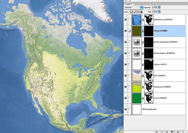
Figure 16. (left) The final map primarily based on MODIS VCF data. (right) The top five Photoshop layers contain supplemental data added to the MODIS VCF base.
Cities are another category requiring outside help on MODIS VCF.
Although VCF depicts large urban areas mostly as bare, they appear
indistinctly. For the North America map we used the USGS’s
one-kilometer-resolution Global Land Cover based on AVHRR as an add-on
(see Appendix B for URL). Placing the AVHRR city data in layer mask
with an associated layer color permitted easy adjustments to color,
opacity, and blending. Looking elsewhere, the water layer extracted
from MODIS VCF may also require replacement. While it is reasonably
good for delineating oceans and lakes, all but the widest rivers appear
as discontinuous strings of pixels. Replacing open water areas and
rivers with rasterized vector data from sources such as DCW is
advisable in most cases. Doing this also requires the removal of the
embedded water from the VCF land cover to prevent it from conflicting
with the new water. We discuss a semi-automated Photoshop technique for
removing embedded water in the next section. The portrayal of open
water areas on natural-color maps also deserves consideration. The
North America map in Figure 16 portrays open
water with hypsometric tints and shaded relief derived from ETOPO2
(2-minute Worldwide Bathymetry/Topography) data. It is ironic that a
mapping style that so stridently eschews hypsography for terrestrial
areas happens to work so well with hypsography in water areas. On the
other hand, since no human has ever seen the ocean basins without
water, portraying them with blue hypsometric tints and shading is the
closest approximation of natural colors that we have.
New MODIS VCF products are in the production pipeline based on more
recent data. The University of Maryland, Global Land Cover Facility
plans to expand the forest and herbaceous categories. Forest (woody
vegetation, more precisely), will include needleleaf and broadleaf, and
evergreen and deciduous subcategories. Herbaceous will include new
subcategories for crops and shrubs. These new data will give
cartographers even more tools to make refined natural-color maps.
|
NEXT: DESIGN
AND PRODUCTION TIPS |