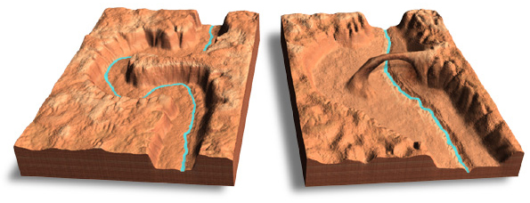
Rainbow Bridge, Utah, is the worldís largest natural bridge. It has
a span of 84 meters, a height of 88 meters, and the bridge itself is 13
meters thick. The base of Rainbow Bridge lies on the geologic contact between
light Navajo sandstone above and reddish-brown Kayenta sandstone below.
The bridge was formed in the incised meander of the canyon by the intermittent
stream eroding a hole through a Navajo sandstone fin.
Block diagram
A block diagram base was used to show the surface elevation diminishing
from an earlier and higher stage (left) to a later and lower stage (right.)
The bottom of the base serves as a benchmark for gauging relative height.
The sides of the base emphasize the horizontal stratigraphy of the Colorado
Plateau, which becomes less visible on the surface of the diagram.
Illumination and cast shadows
The Rainbow Bridge diagram uses lower right illumination for distinguishing the bridge and canyon rims from less important areas. Relief inversion, which sometimes afflicts maps that are illuminated from the lower right, was not a problem because the large scale, vertical exaggeration, and oblique view presents Rainbow Bridge as a 3D diagram rather than a map. Landforms appear in partial profile. The block diagram base is also starkly shadowed, reinforcing the perception of three dimensionality on the modulated terrain surface. And finally, the cast shadow beneath the bridge reminds viewers that illumination originates from the lower right.
Cast shadows are most appropriate on large-scale 3D models viewed from
low elevations. In these situations readers expect to see cast shadows
based on their real world observations . Cast shadows generally look better
with soft edges and low to moderate intensity (darkness). On small scale
maps cast shadows can interfere with oblique hill shading, especially in
steep-sided valleys where the shadows can fall on adjacent illuminated
slopes. This causes valley bottoms to appear indistinct.
Landscape sculpting
A custom DEM of Rainbow Bridge was created because other elevation data were not available at the scale needed for the diagram.Ý The landscape was sculpted from a grayscale image in Photoshop and later extruded in Bryce. Aerial photographs were used for reference when creating the landscape, although it is not an exact representation of Rainbow Bridge. Instead, its purpose is to illustrate generalized geologic processes.
Sculpting the custom landscape started with a flat gray square. Noise, sharpen, and smoothing filters were applied in varying amounts to give the surface an irregular appearance similar to the ìslickrockî country of the Colorado Plateau. The canyons were etched into the DEM by darkening (lowering) selections drawn with the lasso tool. Cracks were painted into the canyon rims using the burn tool with a small sharp edged brush.
DEMs are incapable of representing overhanging topography. The span
of Rainbow Bridge was modeled in Strata StudioPro as a DXF object built
from ovoid ribs and ìskinnedî with a smooth surface. In the next step,
the DXF bridge was imported into Bryce, scaled and positioned to cross
the canyon, assigned the same texture as the sculpted terrain, and rendered.
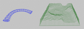
Wireframe view: The DXF model of Rainbow Bridge (left) was placed
on the canyon landscape (right).
Final touchup
Photoshop was used to touchup the final rendered image to remove seams at the base of the bridge and add structural irregularities. The stream was created by erasing the canyon bottom with a small brush, which permitted a blue copy of the DEM to show through.