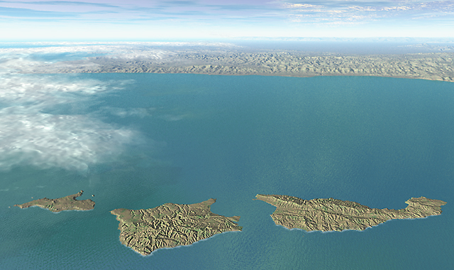
Channel Islands National Park, California
Channel Islands National Park, California
Tom Patterson
Division of Publications
Harpers Ferry Center
US National Park Service
Harpers Ferry, WV, USA 25425-0050
Presented at:
German Society of Cartography: Working Group of High Mountain Cartography
Bielerhöhe, Austria
February 26-March 1, 1998
Abstract/Zusammenfassung
This paper reports on techniques developed by the US National Park Service for the production, presentation, and manipulation of 3D landscapes. Production is based on desktop software and mostly public domain data. The presentation approach strives to combine the aesthetic achievements of traditional illustrators and panoramists with the latest advancements in digital graphics. Complex natural phenomena are presented in a more understandable manner through data manipulation. Specific subjects include: terrain modeling, image enhancement, illumination, vertical exaggeration, image draping, globes, block diagrams, and panoramas.
Diese Abhandlung berichted über technische Verfahren des US National Park Service in der Entwicklung von Produktions-Methoden und deren Handhabungen in der Darstellung von dreidimensionalen Landschaften. Die Produktion ist basiert aufÝ ìDesk-top softwareî und öffentlich zugängigen Daten. Die Handhabungen verbinden herkömmliche, estethische Methoden graphischer Künstler und Panoramisten, mit den neuesten Errungenschaften der digitalen Graphik. Komplizierte natürliche Erscheinungen werden schneller begreiflich gemacht durch die Anwendung von modernen Daten-manipulationen. Besondere Beispiele behandeln: Relief modelierungen, die bildliche Verbesserung, die graphische Beleuchtung, vertikale Aufrisse, digitale Bildverschiebungen, Globen, Blockdiagramme und Panoramas.
Introduction
Traditionally, the US National Park Service has employed panoramic art to illustrate the dramatic landscapes and cultural resources of our national parks. Recently, I began investigating the use of computers to create 3D landscape illustrations. The goal is to produce digital illustrations inexpensively and quickly that rival the aesthetic quality achieved by traditional methods. My paper discusses digital landscape presentation at the US National Park Service.
My approach to production relies on dichotomous technologies: most data derive from GIS and remote sensing sources, which are then processed for final presentation using graphics software. 3D modeling is performed in MetaCreations Bryce 3D. Adobe Photoshop 4.0 is used to prepare and modify Digital Elevation Models (DEMs), manipulate imagery prior to 3D draping with Bryce, and perform post-rendering touch ups. Using graphics software for final preparation makes practical sense because these packages are inexpensive, yield superb graphical output, and are easier to use than GIS; thus allowing more time for creative considerations.
My paper is organized around eight 3D images. Discussion of these images introduces concepts about the manipulation and presentation of digital landscapes. The intent is to provide an overview and avoid minutiae about using software. In a few instances I discuss unique technical procedures in greater detail. I should point out that many of these procedures can be performed similarly with other software.
Although the 3D images to be discussed look different, all share one similarity: the raw data from which they derive have been altered to improve the legibility, aesthetics, and the audienceís understanding of the final image. Todayís software permits us to manipulate geographic reality with unprecedented control and accuracy.
Discussion
Haleakala
Terrain modeling, volcano creation, stream erosion
Colorado
Plateau
Floating landscapes, DEM enhancement, snowline
Crater Lake
Multiple DEMs, light source
North
Atlantic Currents
Globes, spherical mapping, image compositing, vignette
Maui
Panoramas, environment color, water, clouds, vertical exaggeration
Buck Island
Bump mapping, resolution, scale
Rainbow
Bridge
Block diagram, illumination and cast shadows, landscape sculpting
Yellowstone
Color enhancement, lighting, texture, foreshortening
Conclusion
My investigations demonstrated that computer-generated landscape illustrations can be created relatively quickly and inexpensively when compared to traditional production techniques. I was pleased to discover that digital illustrations can rival the attractiveness of traditional illustrations, albeit in a different style. The U.S. National Park Service, recognizing the benefits of automation, has begun publishing digital landscape illustrations in brochures and handbooks, on the Internet, and on CD-ROM. Traditionally produced landscape illustrations will continue to be published. However, the high cost of production and the dwindling number of skilled geographic artists point to a shift toward digital solutions.
The cost of producing digital landscape illustrations is mostly a factor of time. Data preparation consumed about 80 percent of the total time expended for making the landscape illustrations discussed in this paper. Once the data were prepared, however, 3D scene setup and rendering progressed relatively quickly. Modifications were easily made to viewing position, vertical exaggeration, illumination, and color. I needed from one to four days to produce the digital illustrations. Producing similar illustrations by traditional methods may have taken several weeks, depending on the artistís experience. In some cases the cost of digital production was amortized over several projects by recycling the data for animations, virtual reality presentations, and map shaded relief.
The production of digital landscapes has a serious shortcoming: obtaining data. Projects can not proceed without DEMs or imagery, or if their poor quality is beyond repair. For example, I recently had to abandon a 3D mapping project of the Virgin Islands National Park for lack of DEMs. Fortunately, this problem should abate as high quality and affordable (free in many instances) data become more available. Another problem is the steep learning curve for making 3D landscapes of publication quality. I needed several years to learn the techniques outlined in this paper. It is realistic to expect that the learning curve should decrease as software continues to improve and 3D mapping becomes more common.
A simple push-button approach to digital production does not yet exist for making 3D landscape illustrations that are accurate, communicate effectively, and appear realistic. The creator must be familiar with technology, understand the complex relationships between topography and the natural environment, and possess artistic sense. Many of the techniques discussed in this paper were borrowed from traditional art and applied to the digital medium. It is this hybrid approach, combining the speed and accuracy of computers with artistic intuition that holds promise for creating a new generation of beautiful 3D landscapes.