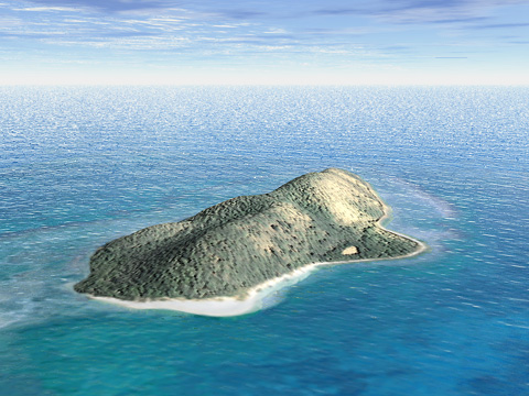
This view looks northeast at 1.6 kilometer-long Buck Island, U.S. Virgin
Islands, its coral reef, and the Caribbean Sea. The 103-meter high summit
can be reached by trails starting from West Beach (foreground). The Marine
Garden protected area occupies the eastern (background) portion of Buck
Island Reef.
Bump mapping
Aerial photographs often look blurred when draped on DEMís, especially
on steep slopes. Bump mapping is a technique for creating texture to counteract
blurring. Bump map textures show miniature highlights and shadows, similar
to shaded relief, wherever image contrast is great. The bump map used on
Buck Island was generated from contrast data in the draped aerial photograph
itself, giving the vegetation a three dimensional appearance. The underlying
DEM was not structurally altered.
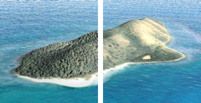
Buck Island with a bump map texture (left) and without (right).
Resolution
The Buck Island scene was constructed from a DEM and aerial photograph
measuring 256 x 256 pixels. Such low resolution data are inadequate for
creating large format panoramas. However, with bump mapping and small format
printing, the landscape appears more detailed than it actually is. Furthermore,
large format panoramas can be created from low resolution DEMs that are
draped with high resolution imagery. The detail of the high resolution
image visually compensates for the DEMís lack of topographic structure.
Large scale
Extremely large-scale 3D scenes that show individual trees, buildings,
and other recognizable objects are difficult to construct from DEMs and
draped imagery. Oblique aerial photographs are often a better solution
for displaying realistic large-scale scenes and can be less expensive to
obtain than producing 3D models.
Construction
The Buck Island scene was constructed from a DEM, an aerial photograph
of the island and its coral reef, and an artificial water plane. The water
plane extends to the horizon and intersects the island at sea level. Terrestrial
portions of the DEM rise above the water plane and the coral reef lies
below the reflective and semi-transparent surface. The scene uses white
illumination and a bright cloudscape to emulate the Caribbean environment.
Illumination originates from the lower right to match the light direction
and shadows on the draped aerial photograph.
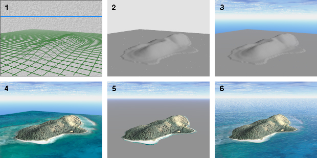
Buck Island genesis: 1) Wireframe DEM, 2) Flat shaded DEM, 3) Clouds and haze, 4) Draped aerial photograph, 5) Opaque water plane, 6) Semi-transparent water plane.