Globes
Globes, in whole or part, are probably the simplest type of 3D map to
design. There is one prerequisite for designing a successful globe: a part
the Earthís horizon must be shown to suggest three dimensionality. Also,
the curved horizon implies a global context, although only a portion of
the Earth is shown. Scenes viewed from an unusual direction or angle often
capture a viewerís interest. However, to be understandable, unorthodox
views should have a familiar geographic context.
Spherical mapping
Spherical mapping is a 3D technique for wrapping 2D images onto round objects. All cylindrically projected cartographic data, including rasterized map line work, can be mapped onto a sphere. Images should have a 2:1 aspect ratio when wrapped on a 360 x 180 degree globe to minimize distortion, although any rectilinear image will do.
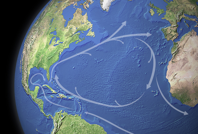
The North Atlantic Currents scene maps a topographic image onto a sphere
primitive. The sphere is structurally intact; mountains do not physically
alter its smooth surface. The illusion of topographic relief derives entirely
from the mapped image. Illumination originates from the upper left on both
the topographic image and 3D scene.
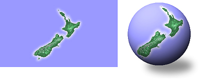
Small world: A cylindrical map of New Zealand (left) wrapped on
a sphere (right).
Image preparation
The image used in the North Atlantic Currents scene was composited in
Photoshop from five elements. All share a common resolution (12 pixels
per degree), the Plate Carrée projection, and are in register. Each
element was placed on its own layer where color, sharpening, opacity, and
blending mode were adjusted. A land/water mask was used for isolating land
and water areas for selective manipulation. Mountain tops (on land) were
lightened with a snow mask that subtracted value from the satellite image,
but not from the hill shading.
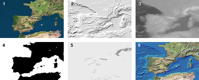
Image elements: 1) The Living Earth satellite image, 2) Hill shading
of land and water areas, 3) Elevation tints of land and water areas, 4)
Land/water mask, 5) Snow mask, 6) Final composite image. The Living Earth
image is a copyrighted product of The
Living Earth, Inc.
Vignette
An atmospheric vignette follows the Earthís horizon against the black of outer space. It was created in Bryce from a duplicate of the Earthís sphere. The duplicated sphere was left in its original position, increased slightly in size, and assigned a transparent blue texture (with fuzzy edges) for final rendering.