Natural Earth II is a raster map dataset that portrays the world environment in an idealized manner with little human influence. Imagine the urban landscapes of New York, Paris, and Tokyo restored to temperate forest, southern Russia as the open steppe it once was, and the Amazon Basin covered with unbroken rainforest. A successor dataset to the original Natural Earth, Natural Earth II owes its inspiration to the classic physical maps published by the National Geographic Society.
The softly blended colors of Natural Earth II make it a suitable base for general reference mapping, including historical maps, because it shows the physical world much as it looked before the Anthropocene, the modern era when humans have become the dominant influence on climate and the environment.
Natural Earth II data comes in several versions for use with cartography and GIS software. It is downloadable for free at naturalearthdata.com.
Discussion
Natural Earth II derives from the original Natural Earth dataset and improves it by transforming fragmented land cover into generalized environmental zones. The primary reason for doing this was to fulfill a graphical need for cartography. The revised dataset replaces the contrast and noisiness of land cover patterns with smoothly blended natural colors. Natural Earth II attempts to do with environmental data what hypsometric tint maps do with elevation data—provide an informative, visually appealing, and unobtrusive base for making general-purpose maps.
Potential Natural Vegetation
The way that Natural Earth II depicts the world is familiar to anyone who has seen a physical map in a National Geographic Society atlas. Developed by Tibor Tóth in 1971 and expanding on the pioneering work of Hal Shelton, colors on the National Geographic maps show the natural vegetation (and non-vegetated environments) that potentially would exist without human influences on the land. Tóth used potential-vegetation maps compiled by A.W. Küchler, a prominent bio-geographer who held positions at several U.S. universities in the 1950s and 60s, as a guide for his expressive hand-painted work.
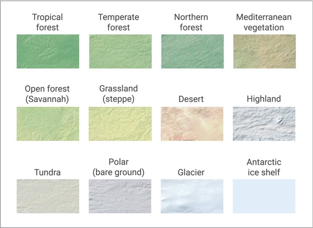
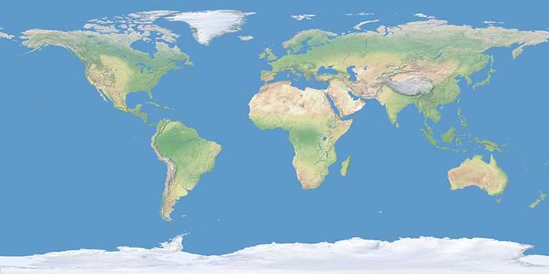
Natural Earth II
World environment map in natural color


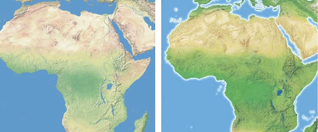
(left) Natural Earth II. (right) A National Geographic physical map painted by Tibor Tóth.
Compared to land cover that shows what exists on the land at a specific time, potential natural vegetation is a theoretical concept. Potential-vegetation maps assume that modern human-altered environments are a superficial and temporary phenomenon when viewed through the long lens of time. For example, representing Las Vegas with warm desert beige ignores today’s urban landscape veneer. New York City in the humid East would appear as forest green. Tóth’s palette for portraying potential vegetation uses colors that readers—even city dwellers with little day-to-day contact with the natural world—intuitively associate with the natural environment. Potential-vegetation maps depict the untrammeled natural environment not as it is, but as we think or imagine that it should look.
Making Natural Earth II
Creating Natural Earth II, a digital product, involved manual techniques similar to those developed by Tóth almost 50 years ago. The starting point for production was the original Natural Earth land cover dataset created by the author in 2005. Modifications to the data in Adobe Photoshop included painting with the Brush tool, cloning, applying color adjustments, and masking.
Polar, desert, and highland environments in Natural Earth II are mostly the same as those in the original Natural Earth. These environments tend to have little human population and are still relatively intact, or affected in ways not discernable on a small-scale map. Modifications to arid environments involved replacing light yellow-green irrigated croplands with desert beige. By contrast, humid forest environments in the mid-latitudes and tropics—places most favored for human habitation—received major modifications. In these areas, forest cover was restored to its estimated original extent before the significant growth of human population and activity in the last two or three thousand years.
Forest restoration
Restoring forest cover to its original extent was an inexact exercise involving multiple sources of information and visual interpretation. The best indicators that forest once existed in an area are remnant patches of forest that exist on contemporary land cover data. For example, the original Natural Earth dataset shows scattered patches of forest throughout northwestern Europe on a landscape otherwise dominated by urban and agricultural land. This information, plus the prevailing moist climate and common knowledge that forests once covered the entire region, made the decision easy. A continuous green tone fills northwestern Europe on Natural Earth II.
Determining original forest extent was more difficult for drier areas where remnant forest cover is scarce today, such as central India and northeastern Brazil. Classic physical geography references helped with this task, including Küchler potential-vegetation maps, Köppen climate maps, and precipitation maps, all obtained from Goodes World Atlas, 1978.
Helpful online resources included the Global Distribution of Original and Remaining Forests, a map published by UNEP-WCMC. The Degree Confluence Project is a website where GPS users post photographs of the 11,076 places on Earth where lines of latitude and longitude intersect on land. Photographic evidence of forest at a coordinate intersection today is strong evidence that natural forest existed there in pre-modern times.
In drier forested regions, denser green tones occupy river valley bottoms and upland areas that are presumably moister. In some areas where small but significant forest stands exist, such as the Rocky Mountains of the western United States, appear with slightly more green. Conversely, in large regions with uniform forest cover, areas with relatively fewer trees received emphasis. The Black Belt prairie that traces a crescent through Mississippi, Alabama, and Georgia in the southeastern United States is one such example. These subtle modifications present a more complete picture of the natural environment and produce a more visually interesting map.
A moving target
In mapping potential-natural vegetation difficult questions arise about how far back or ahead in time one should go. Even without human influence, the natural environment is in constant flux. Southwestern Alaska, for example, is now covered with tundra vegetation even though the climate there is just warm enough to support forest cover—it is hypothesized that not enough time has elapsed since the end of the last ice age for trees to colonize this remote area far from other forests and seed sources. In other regions, vegetation change can be rapid. The semi-arid Sahel bounding the southern edge of the Sahara is greener today than it was a few decades ago because of increased rainfall. The idea that plant succession will eventually lead to a climax community that will remain in stable equilibrium for a long time is refuted by scientists today because natural disturbances are not as rare as once thought.
When human influences are factored in, mapping potential-natural vegetation becomes even more complicated. That industrial societies have altered natural landscapes significantly is not debatable—the manicured suburb where I live is evidence of this. However, should the more benign activities of indigenous peoples in former times, such as intentionally lighted fires to clear forests or drive game, be a valid consideration for mapping potential-natural vegetation? For example, fires set by the pre-Columbian inhabitants of North America expanded the extent of the Great Plains grasslands into adjacent forestlands.
Alan Weisman in The World Without Us (2007) deconstructs how contemporary cities would revert to a natural state relatively quickly if the human species were to suddenly disappear from Earth (a scenario that is both troubling and fascinating). According to Weisman, in a matter of days weeds would start to grow in the cracked pavement of Manhattan, establishing a beachhead for other plants and the eventual return of forest. Mid-latitude forest environments, such as New York City, are resilient to change. More fragile environments elsewhere might never fully recover to what they once were because of human influences. Consider the drier parts of the Hawaiian Islands where introduced kiawe (mesquite) trees thrive on land that once was native grassland, a vegetation type unlikely to return ever again.
The small map scale, vegetation boundaries with fuzzy edges, and generalized classification of Natural Earth II partially circumvents these problems.
Classification
Using a generalized classification brought other benefits to Natural Earth II. Because it is a base for mapmaking, a generalized classification with fewer environmental colors improved legibility. A base map that is too colorful and varied can distract from thematic information overlaid on it. A practical concern was limiting the shades of green representing forest types to a number that a reader could easily differentiate, a task made more difficult by colors that merge together on the map just as forest types do in nature.
Understandable terminology was another reason for using a generalized classification. Many land cover and vegetation maps use scientific terms that are unfamiliar to average readers. In the Natural Earth II classification, simpler terms were preferred. For example, consider the broad forest belt that encircles the earth in the northern hemisphere immediately south of the Arctic Circle. Natural Earth II calls this environment northern forest and depicts it with cool green. For the intended audience, the author rejected the terms boreal and sub-arctic as too arcane. Other terms for common tree types found here were not inclusive enough. Needle leaf and coniferous do not take into account the many birch and aspen trees that comprise northern forests. In addition, the presence of these broad-leaf deciduous trees and larch, a needle-leaf deciduous species, ruled out using the term evergreen.
Terrestrial environment classification used for Natural Earth II.
The Natural Earth II classification contains three forest types (tropical, temperate, and northern) and two types of partial forest, (Mediterranean vegetation and open forest/savannah). Coloring these forests involved visually comparing Köppen climate maps and the restored forest extent on Natural Earth II and applying an assigned color in Photoshop where they coincided. For example, brownish green Mediterranean vegetation found in scattered pockets around the globe correlates with Mediterranean (Cs) climates in Köppen’s system. Following this approach, northern forest correlates to Köppen’s Db, Dc, and Dd climates, tropical forest to Af and Am climates, and temperate forest to several intermediate climates in his system.
A generalized environment classification also must come with omissions. Natural Earth II does not classify shrub land or wetlands as distinct environments. Shrub land—a vegetation type that gets little respect—is subsumed by Mediterranean vegetation, open forest, grassland, and desert in the Natural Earth II classification. Wetlands are also part of other classifications. The Everglades of Florida appear as grassland and the bogs of the Western Siberian Lowlands, the largest wetlands on earth, appear as lightly tinted northern forest.
Delineating the boundary between grassland (steppe) and forest environments was difficult. Natural Earth II reclassifies herbaceous land cover (a category that includes croplands and pasture) in the original Natural Earth dataset as grassland. Factoring in the absence of intentional burning by humans, forest cover encroaches on and blends softly into the Hungarian Alföld, Great Plains of North America, Llanos of Venezuela, and other grasslands of the world.
Caution
Natural Earth II is an artistic interpretation of our planet in a more natural state than that of today. It is not scientific data.