Adding XYZ Tiles to MAPublisher Maps
This tutorial introduces a quick way to add satellite images and raster reference maps, available as XYZ Tiles, to Illustrator/MAPublisher documents. The imported images will register with your map regardless of which projection it uses.
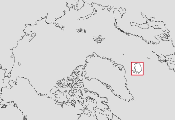
Although the technique is most useful for large-scale mapping, my demo uses the small-scale map below in the Polar Azimuthal Equidistant projection. I will add a Google satellite image to the area indicated by the red box. It demonstrates how XYZ Tiles can transform to a much different map projection.
Besides Adobe Illustrator and MAPublisher, you will need QGIS and a good internet connection to do this tutorial.
Illustrator
1) On your map, create a new MAPublisher map layer. Assign "Area" as the feature type. Call the layer "Box".
2) Use the AI rectangle tool to draw a rectangle over your area of interest on the Box layer.
3) From the Map Views fly-out menu (upper right), export the Box layer as a shapefile.
QGIS
4) Launch QGIS. Drag the exported Box shapefile into the Map View. Alternatively, you can add it via the Menu Bar: Layer/Add Layer/Add Vector Layer
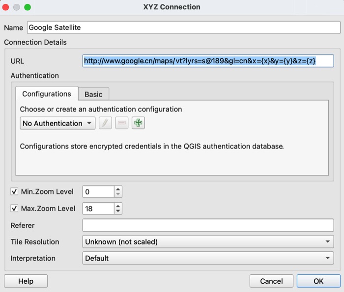
5) In the Browser panel, right-click on XYZ Tiles to open a new connection. Call the new connection Google Satellite or something similar. Copy and paste the URL below into the URL field. Then click OK.
http://www.google.cn/maps/vt?lyrs=s@189&gl=cn&x={x}&y={y}&z={z}
Introduction
Tutorial
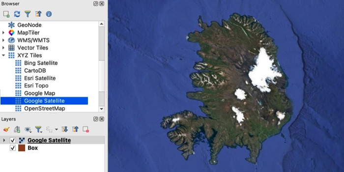
6) Go to the XYZ Tiles list in the Browser panel. Double-click Google Satellite.
A Google satellite image will appear as a new layer above the Box layer after a few moments. On my example below, note how the Iceland image has transformed to the Polar Azimuthal Equidistant projection.
Bing Satellite
http://ecn.t3.tiles.virtualearth.net/tiles/a{q}.jpeg?g=1
Google Satellite
http://www.google.cn/maps/vt?lyrs=s@189&gl=cn&x={x}&y={y}&z={z}
Google Map
https://mt1.google.com/vt/lyrs=r&x={x}&y={y}&z={z}
Esri Satellite
https://server.arcgisonline.com/ArcGIS/rest/services/World_Imagery/MapServer/tile/{z}/{y}/{x}
Esri World Topo
https://server.arcgisonline.com/ArcGIS/rest/services/World_Topo_Map/MapServer/tile/{z}/{y}/{x}
CartoDB
https://cartodb-basemaps-a.global.ssl.fastly.net/light_all/{z}/{x}/{y}.png
Open Street Map
http://tile.openstreetmap.org/{z}/{x}/{y}.png
Russian Topos
http://88.99.52.155/cgi-bin/tapp/tilecache.py/1.0.0/topomapper_v2/%7Bz%7D/%7Bx%7D/%7By%7D.jpg
Wikimedia
https://maps.wikimedia.org/osm-intl/{z}/{x}/{y}.png

Illustrator
8) Open your Illustrator map. Use File/Import Map Data/Import Map Data to bring in the GeoTIF that you exported from QGIS. The Google Satellite image will align to your vector map data. Happy mapping.
Additional XYZ Tiles
7) Go to the Menu Bar and select Project/Import-Export/Export Map to Image.
In the window that appears, ignore all fields except for Resolution. I usually start with 500 DPI and will go even higher to obtain more detail, although doing this bloats file sizes. Save the image as a TIF.
Contact me
Do you know of XYZ Tiles that I should add to the list? Drop me a line. Thanks!
Tom Patterson Bio