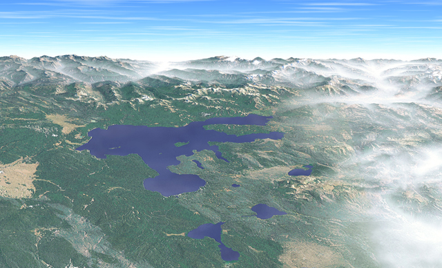
Yellowstone Lake, the largest mountain lake in North America, is visible
in the center of this east-looking view from a vantage point about seven
kilometers above Old Faithful geyser. Framing the horizon are the 3,300-meter
peaks of the Absaroka Range and the fog-filled Yellowstone River valley
(upper right.) Recent forest fires, driven by southwest winds, have left
gray scars on the lodgepole pine forests of the Central Plateau (lower
left.)
Color enhancement
The Yellowstone scene was constructed from a natural color Landsat image,
draped on a DEM. In its raw form the Landsat image was unsuitable for presentation.
Lakes were nearly black, forests were more gray than green, barren ridges
were yellow, and dark shadows covered steep slopes. Photoshopís color adjustment
tools were used to correct the Landsat image before rendering the final
scene in Bryce. Despite adjustments, colors continued to look unnatural
in the lower right corner. Fog, created from flattened spheres mapped with
transparent white texture, disguised the problem.
Lighting
Illumination originates from the lower right to match the Landsat imageís
southeast light source. Excessive shadowing (shadows from 3D lighting combine
with shadows on the Landsat image) was avoided by elevating the light source
close to the zenith.
Texture
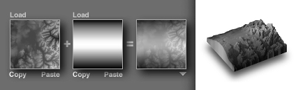
Bump map texture enhances surface detail in the Yellowstone scene. The
bump map was created from a grayscale copy of the Landsat image and, in
Photoshop, a light amount of uniform noise was added to forested areas.
When the bump map image was imported into Bryce as an alpha channel, the
noise created the illusion of an irregular forest canopy on the otherwise
smooth surface.
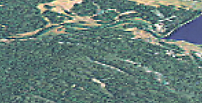
This enlargement shows the tree texture created from bump mapped
noise. Pixelization dissappears when printed at smaller size.
Foreshortening
Problem
The horizon is essential for making a panorama look realistic. However, to show the horizon, a panorama must be viewed from a low elevation by an imaginary camera. The low elevation view limits visibility in mountainous areas where foreground topography obscures the background. Raising the viewing elevation solves the problem of obscured topography, but the horizon disappears and realism is diminished.
Solution
The panoramas painted by Heinrich Berann combine map-like readability and a realistic horizon by using foreshortening, a traditional art technique. Applied to a panorama, foreshortening gradually flattens the landscape deeper into the scene until the horizon appears. Although geographic reality has been manipulated for graphic effect, the final results look convincingly realistic.
Digital implementation
Foreshortening was introduced to Yellowstone by warping the DEM on a
convex arc, bulging the foreground toward the viewer, and flattening the
background. Warping was produced by blending the DEM with a linear gradient
that changed from black (front) to white (middle) to black (back). It is
the gradient that produces a convex arc when extruded in a 3D program.
Varying the blending opacity between the DEM and linear gradient controls
how convex the DEM will be.
Blending the Yellowstone DEM with a gradient (left) produces a convex
DEM (right).
In the final step, the convex DEM was imported into the 3D environment of Bryce. The DEM was positioned vertically with its back edge aligned to the horizon and rotated horizontally so that its front faced the viewer. Once positioned, apparent foreshortening could be increased or decreased by rotating the DEM on the axis perpendicular to the horizon.
Concerns
A convex DEM can only be viewed from its front or back, perpendicular to the axis of curvature. Other viewing directions look unrealistic because the curved surface of the DEM does not synchronize with perspective within the scene. Any changes to the viewing direction, however small, require the creation of a new convex DEM.
Blending a DEM with a linear gradient can degrade topographic detail
because Photoshop has only 256 grayscale levels available for displaying
height data. Typical symptoms of DEM degradation are banding in flat areas
and terrain generalization. Fortunately, draped imagery and procedural
textures can be used to disguise poor quality DEMís.
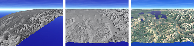
The convex Yellowstone DEM reveals its curvature in side view (left). The landscape shows distance foreshortening when viewed from the front (middle) and looks more natural when draped with imagery (right).