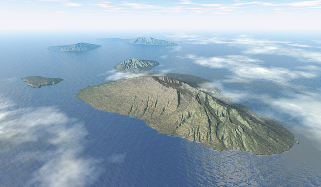
The 3,056-meter summit of Haleakala dominates this northwest looking
view of Maui, Hawaii, and its neighbor islands (from left to right) Kahoolawe,
Lanai, and Molokai. West Maui is visible behind Haleakala; they are joined
by a low isthmus partially obscured by clouds. The Kaupo lava ramp (foreground)
descends to the ocean through a gap in the rim of Haleakala Crater.
Panoramas
Panoramas are the most realistic of 3D landscapes. The characteristics of panoramas vary, although most include a horizon and are cropped within a rectangular frame.Ý Other characteristics include: atmospheric haze, clouds, and precipitation; dramatic lighting; shadows; and realistic land and water textures. Emphasis is placed on aesthetics.
Island scenes are the easiest type of panoramas to create. Realistic
water and sky settings are pre-loaded in many 3D programs, extending the
panoramaís environment to the neatline. Preparationóobtaining data, translating
file formats, and registering DEMs and imageryóis more difficult when panoramas
are constituted entirely of land.
Environment color
Many graphical 3D programs, including Bryce, are principally designed
for the production of fictional and surreal landscapes. Earth-bound cartographers
must use restraint when selecting environmental colors. Illumination looks
best as white, light gray, or light yellow-white. Shadows (derived from
the ambient color) should be light gray or light blue-gray. Haze should
be white, light gray, or light blue. Illumination, shadow, and haze colors
interact with one another within a scene.
Water
The frequency and amplitude of waves should compliment the scale of
nearby land areas. Waves should be de-emphasized or omitted on most small
scale panoramas. In the Maui panorama individual waves are visible only
in the foreground, and they are exaggerated in size when compared to the
islandís 77-kilometer length.Ý Reflectivity was assigned to the water texture
to allow the water, islands, and clouds to interact with one another in
as natural a way as possible.
Clouds
3D cloudscapes are often beautiful. However, the purpose of most panoramas is to show landscapes; therefore, clouds should be used with great moderation. As a general rule the sky should occupy 25 percent or less of a panoramaís total area.
Clouds can be used for aesthetics and to direct a viewerís attention within the panorama. For example, the Maui image uses clouds for graphic balance, to show northeast trade winds blowing from the upper right, and to hide unattractive parts of the scene. A symmetrical wave pattern, which looked artificial, was hidden by a cloud in the lower left corner. The randomness of nature is subliminally suggested when clouds obscure small, preferably unimportant, parts of the main landscape.
Clouds in the Maui panorama were created by two methods. The high clouds
above the horizon were created from a plane that reaches to infinity displaying
an algorithmic texture. The clouds below the horizon were created from
flattened 3D spheres assigned a texture that is fuzzy, turbulent, white,
and transparent. Both varieties of clouds are veiled by environmental haze
as they approach the horizon.
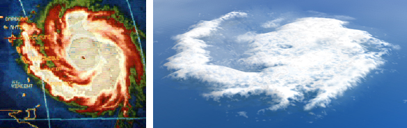
Clouds can be created from raster images. The satellite image of
Hurricane Hugo (left) was extruded and mapped with a fuzzy white texture
(right).
Terrain manipulation
The islands in the Maui panorama were created from three separate DEMs
mapped with the same procedural texture. Lanai and Molokai were created
from lower resolution DEMs, detail was not needed in the distance, and
their scale was increased to 120 percent of original size to counteract
the diminishing effects of haze and perspective. Additionally, Lanai and
Molokai were rotated 10 degrees (horizontally) to show their profiles better
as they appear from West Maui, the popular vantage point for viewing the
islands.
Vertical exaggeration
Determining a landscapeís vertical exaggeration is a subjective decision based on map scale, relative relief, viewing elevation, topographic characteristics, and intended function. On most 3D scenes the vertical exaggeration ranges from 150 to 300 percent of original scale. Some extremely high mountains require no vertical exaggeration. The greatest vertical exaggeration is generally needed for small scale scenes, with low relative relief, which are viewed from high elevations. Landscapes with too little vertical exaggeration can look uninteresting. Landscapes with too much vertical exaggeration can distort grotesquely resulting in small scale DEMs that spike upwards. Large scale DEMís become stretched, data imperfections magnify, and draped imagery blurs.
The exact amount of vertical exaggeration used for the Maui scene is
unknownóBryce does not provide this informationóprobably it is 200 percent
of original scale. Determining vertical exaggeration is ultimately a graphical
decision. The landscape must look right regardless of its numerics.
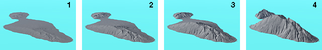
Vertical exaggeration doubles on each successive Maui image reading
from left to right. The vertical exaggeration of image 3 was used for the
final Maui panorama.
Final Photoshop touchup
White surf along Mauiís coast was created by subtracting tone with the eraser tool and a small hard-edged brush. Volcanic gray was blended into the summit of Haleakala with the de-saturation tool.