Terrain modification
Digital landscapes can be shaped like virtual modeling clay, permitting
todayís landscapes to be projected into the future or reverse-engineered
into the past. Landscape alterations are accomplished in Photoshop by graphically
modifying the surface of a grayscale Digital Elevation Model (DEM). Each
pixel in the grayscale DEM corresponds to a sampled elevation point with
light pixels showing high elevations and dark pixels low elevations. It
is the relative value (height) of pixels in a DEM that defines a landscapeís
appearance when it is extruded in Bryce and other 3D software.
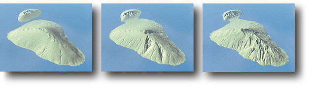
The Haleakala sequence at the top of this page started with the image
on the right, an unmodified U.S. Geological Survey (USGS) DEM of Maui shown
with about 2:1 vertical exaggeration. The older images of Maui (left and
middle) were made by cloning copies of todayís DEM and selectively applying
filters and paint effects in Photoshop.
Terrain modification requires an understanding of geomorphology, artistic trial and error, and frequent switching between Photoshop and Bryce. Mistakes are common and intermediate backup copies are a necessity.
Maui DEM: Elevations are represented by 256 grayscale levels in the
8-bit raster image.
Volcano creation (comments refer to the color illustration at the top of this page)
1) The smooth-sloped shield volcano (left) is slightly higher and more expansive than todayís island (right). Erosion was removed from todayís DEM by cloning (with the rubber stamp tool) slope surfaces into adjacent valleys and using gaussian blur to remove vestigial surface irregularities. Lightening was applied to all land areas to raise the elevation. The isthmus connecting East Maui and Haleakala (foreground) and West Maui (background) was lowered below sea level by darkening the DEM with the burn tool.
2) The caldera was created by drawing a hard-edged selection (with the lasso tool) at the summit. Slight darkening of the selected area recessed the collapsed caldera floor. The process was repeated to create the small caldera nested within the first.
3) Cinder cones were created by drawing soft-edged circular selections (with the lasso tool) which were lightened to elevate cone-shaped hills. Next, the circular selections were contracted by several pixels and darkened to depress the summits. Excessive symmetry was avoided by drawing the circular selections withÝ irregular edges and by dodging and burning the slopes of the cinder cones with a small brush.
4) Gaussian noise was lightly applied to the entire DEM surface to create
a natural texture.
Stream erosion
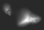
Nascent stream erosion was etched into the smooth volcanic slopes by painting dark sinuous tones with airbrush and dodge tools. The dark tones were applied with multiple light brush strokes, moving in an uphill direction, which mimicked the growth of drainage basins over time. Larger brush sizes were used to hollow out the upper drainage basins to create amphitheater valleys.
Registration between the three Haleakala DEMís was achieved using Photoshop
layers. Each DEM was placed on its own transparent layer where it was used
as a template for painting drainage on the next DEM placed on the layer
above.
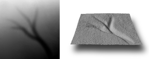
Drainage airbrushed on a grayscale DEM in Photoshop (left). The dark lines etch into the landscape when the DEM is extruded in a 3D program (right).