Colorado Plateau
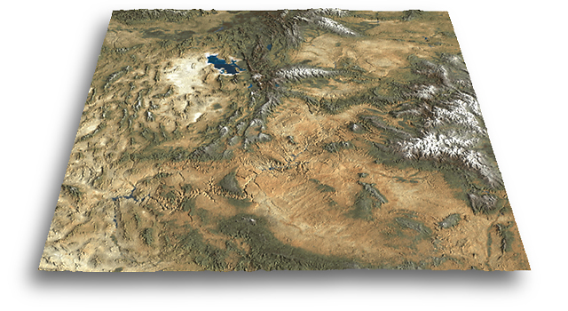
The Colorado Plateau and the Grand Canyon occupy the foreground of
this north oriented view of the western United States. Great Salt Lake
and the Bonneville Salt Flats can be seen in the northwest. To the west
lies the north-south trending basin and range physiographic province. The
snow-capped Rocky Mountains rise in the east. Elevations within the scene
range from 150 to 4,400 meters above sea level.
Floating landscapes
The Colorado Plateau scene is shown as a landscape floating in isolation
from contiguous geographic areas. Floating landscapes are common and offer
advantages for 3D landscape presentation: 1) data requirements are finite,
2) the sides of a scene converge toward the background, reinforcing perspective,
3) the crenelated edges show elevation differences providing visual cues
about three dimensionality, and, 4) landscapes can be viewed from high
or low camera elevations with equal effectiveness.
DEM enhancement
The scene was created from a square DEM, 10 degrees per side, with one
kilometer resolution. When initially rendered, canyons appeared with rounded
edges because of the DEMís low resolution. Photoshop was used to enhance
the canyons on the DEM prior to rendering the final scene in Bryce. A light
application of the unsharp mask filter helped define the rugged canyon
rims. Mountain peaks were not sharpened because of their tendency to spike
unnaturally upwards.
Snowline
Colors on the Colorado Plateau surface derive from a satellite image,
with one kilometer resolution, which was draped (mapped) on the DEM. The
satellite image shows water and vegetation zones. The copyrighted satellite
image, windowed from a world database, is a product of Arc
Science Simulations, Inc.
Problem
The color of elevation-influenced vegetation zones in the western United
Statesóbeige desert lowlands and green montane forestsócontradicts the
cartographic convention for showing hypsometric tints, which usually are
dark green lowlands and pale highlands. When highlands are cloaked in dark
green (a visually recessive color), as is the case with the Colorado Plateau,
3D properties become subdued.
Solution
An artificial snow line (white) graphically elevates the loftiest mountain
ranges above the green forests. The snow was added to the satellite image
with Photoshop before rendering the final scene in Bryce. It was created
by masking the satellite image with an inverted copy of the grayscale DEM,
which removed color from the mountain tops, simulating snow. The snow mask
can be made to appear gradual or abrupt, opaque or translucent, by subtly
adjusting Photoshopís curves.
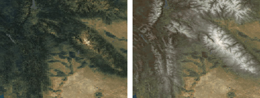
Dark forests obscure mountains on the original satellite image (left).
Color adjustments and a snow mask help to define mountains (right).
Procedural texture
Draped images on DEM surfaces often look unnaturally smooth, especially
when stretched by vertically exaggerated relief. Adding a procedural texture
can give the scene a more organic look. The illusion of desert rubble was
added to the Colorado Plateau with a subtle sandstone texture selectively
applied to flat lowland areas.
Return